


SityTrail hiking trail GPS
SityTrail hiking trail GPSの説明
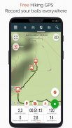
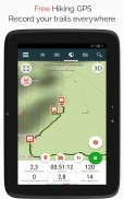
世界中のすべての道を探索してください
•冒険のHDおよびジオタグ付きの写真を撮りながら、トレイルを記録します。
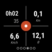
•移動距離、Km-努力、平均速度、消費カロリーなど。
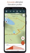
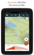
•正確な高度計、高低差の計算、現在地を表示する標高プロファイル。
•追跡しているトレイルのパスから外れたときのアラーム。後戻りする必要はもうありません!
•テキスト読み上げによる関心のあるポイントの自動トリガー。
•無料のアカウントを作成すると、すべてのデータがすべてのデバイスのどこからでも利用できるようになります。
•当社のウェブサイトからトレイルや興味のあるポイントを簡単に作成できます。
•オンラインエディターを使用して、PC / MacのWebブラウザーを使用して独自のトレイルを作成し、スマートフォンから直接それらにアクセスして、地上でそれらを体験します。
•自分のリストで自分のトレイルと関心のあるポイントを並べ替えて分類します。
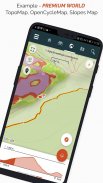
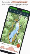
さらに進んでプレミアムユーザーになりましょう!
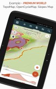
•オフラインで使用するために世界の地形図をダウンロードします。
•GRハイキングコース、ヨーロッパのハイキングルート、巡礼者のためのサンティアゴデコンポステーラルートなどを発見します。
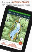
•IGNフランス、IGN / NGIベルギー、IGNスペイン、swisstopo、オーストリア、米国(USGS地形図)、カナダ(Toporama)から選択した地形図を追加します。
•また、フランスのGreenwayネットワーク、ベルギーのRavel、ヨーロッパのサイクリングルート、フランダースとオランダのノットポイントネットワークなど、すべてのサイクリングネットワークを見つけることができます。
•そして冬には、名前の付いたすべてのスキー場を発見してください。
•SityTrailメンバーおよびコミュニティからのトレイルの公開カタログにアクセスします。
•交差点での残りの距離と時間および音声指示の計算を備えた高度な追跡およびガイド機能。
•さらに進んで、お気に入りのトレイルをテキスト、写真、ビデオリンクを含む実際のマルチメディアガイドに変換し、SityTrailコミュニティと共有します。
•独自のハイカーコミュニティを作成し、メンバーとニュースフィードを管理します。
•当社のWebサイトを介して、トレイル編集用の高度な機能を使用してトレイルを作成します。
•QRコードを使用してPDF形式で証跡を印刷します。 (A4、A3)。
•SityTripモジュールからジオタグ付きのウィキペディアの記事にアクセスします。
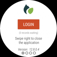
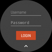
WearOSウォッチに証跡を記録する
Wear OSウォッチに、スタンドアロンモード(Androidスマートフォンに接続されていない)またはペアモード(Androidスマートフォンに接続されている)で証跡を記録できます。
このアプリケーションでは、時計をスタンドアロンモードで使用しているときに、既存のSityTrailアカウントに(最も左側の画面から)ログインすることもできます。
重要な情報
•一部の機能にはインターネット接続が必要です。
•GPSを長期間使用すると、バッテリーの残量が少なくなる可能性があります。
SityTrail hiking trail GPS - バージョン 12.15.8.3
(24-06-2025)SityTrail hiking trail GPS- APK情報
APKバージョン: 12.15.8.3パッケージ: com.geolivesSityTrail hiking trail GPSの最新バージョン
他のバージョン


同じカテゴリのアプリ


その他のおすすめ...


